CUET-PG SERIES Applied-geography-and-geoinformatics
General Cartography
9 previous year questions.
Volume: 9 Ques
Yield: Medium
High-Yield Trend
9
2024 Chapter Questions 9 MCQs
01
PYQ 2024
medium
applied-geography-and-geoinformatics ID: cuet-pg-
Identify the correct statements about scale and representation of information on maps:
(A) Increasing the size of the denominator of R.F. means making each detail smaller and less exact on a map.
(B) A map always gives every detail to scale.
(C) As more area is covered by the same size map, exactness of delineation increases and more details can be shown.
(D) All maps give areas covered by spatially distributed details to the scale shown within the scope of each map unit.
Choose the correct answer from the options given below:
1
(A), (B) and (D) only.
2
(A), (B) and (C) only.
3
(A) and (D) only.
4
(B), (C) and (D) only.
02
PYQ 2024
medium
applied-geography-and-geoinformatics ID: cuet-pg-
Arrange the following reference number of topographical maps/sheets in order of scale from larger to smaller:
(A) 44 A/10/5
(B) 53 B/10
(C) 64C
(D) 45
Choose the correct answer from the options given below:
(A) 44 A/10/5
(B) 53 B/10
(C) 64C
(D) 45
Choose the correct answer from the options given below:
1
(A), (B), (C), (D)
2
(B), (A), (C), (D)
3
(B), (A), (D), (C)
4
(C), (B), (D), (A)
03
PYQ 2024
medium
applied-geography-and-geoinformatics ID: cuet-pg-
Which of the following landforms is represented in the diagram given below?
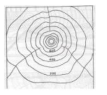
1
plain
2
V-shaped valley
3
U-shaped valley
4
hill
04
PYQ 2024
medium
applied-geography-and-geoinformatics ID: cuet-pg-
Bonne's projection is a modified version of the:
1
Cylindrical projection
2
Zenithal projection
3
Mercator's projection
4
Simple conical projection
05
PYQ 2024
medium
applied-geography-and-geoinformatics ID: cuet-pg-
In a Zenithal projection a ___ is made tangent to a transparent globe.
1
plane
2
cone
3
circle
4
cylinder
06
PYQ 2024
medium
applied-geography-and-geoinformatics ID: cuet-pg-
If two points located 10 kms apart on ground are shown 5 cm apart on a map, then the scale of the map is
1
1 : 200
2
1 : 20000
3
1 : 200000
4
1 : 2000
07
PYQ 2024
medium
applied-geography-and-geoinformatics ID: cuet-pg-
Scale is commonly used to evaluate topological and metric properties of the geographic features on a map except.
1
Distance
2
Direction
3
Connectivity
4
Contiguity
08
PYQ 2024
medium
applied-geography-and-geoinformatics ID: cuet-pg-
Match List I with List II
Choose the correct answer from the options given below:
| LIST I | LIST II |
|---|---|
| A. Million sheet | I. 4°x4° |
| B. Quarter-inch sheet | II. 1°x1° |
| C. Half-inch sheet | III. 30'x30' |
| D. Special sheet | IV. 7'30"x7'30" |
1
(A)-(I), (B)-(II), (C)-(III), (D)-(IV)
2
(A)-(I), (B)-(III), (C)-(II), (D)-(IV)
3
(A)-(I), (B)-(II), (C)-(IV), (D)-(III)
4
(A)-(III), (B)-(IV), (C)-(I), (D)-(II)
09
PYQ 2024
medium
applied-geography-and-geoinformatics ID: cuet-pg-
Identify correct statements about flow diagrams:
(A) When part of the commodity is diverted to a different direction, the main flowline also becomes thicker proportionately.
(B) The thickness of the lines is determined by the volume or quantity of flow.
(C) Movement of goods can be shown only in one direction.
(D) These are not suitable to represent international, national or regional flow of various commodities.
Choose the correct answer from the options given below:
1
(B) and (D) only.
2
(A), (B) and (C) only.
3
(A), (C) and (D) only.
4
(A) and (B) only.
About General Cartography - CUET-PG
General Cartography is a vital chapter for CUET-PG aspirants. Mastering the concepts covered in this chapter is essential for securing a top rank.
By rigorously practicing the previous year questions associated with this chapter, you can identify high-yield topics, understand the examiner's perspective, and boost your confidence during the actual exam.
Frequently Asked Questions
Why focus on General Cartography PYQs?
Analyzing PYQs for this specific chapter reveals the most frequently tested concepts and the typical complexity of questions, allowing you to tailor your study plan efficiently.
How to best use this analysis?
Review the topic breakdown to see which sub-topics within General Cartography carry the most weight. Then, tackle the questions iteratively to solidify your understanding.