Remote Sensing
25 previous year questions.
High-Yield Trend
Chapter Questions 25 MCQs
Field of view (FoV) = 2 degrees
Instantaneous FoV = 1 milli-radian
Time to scan one full scanline = s
Height above ground = 100 km
The dwell time for a single pixel of this sensor is ............................. s. (Rounded off to 2 decimal places)
The spectral reflectance curves of three materials (A, B, and C) are shown, along with three wavelength bands X, Y, Z. Which of the following statement(s) is/are CORRECT?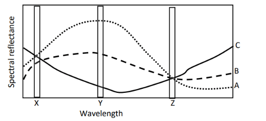
To visually distinguish between a river channel and a canal on an image, having similar widths and located in the same area, the most important parameter used is _______________
Number of detectors = 3000
Height above the ground = 900 km
Swath on the ground = 30 km
The spatial resolution of the sensor is _____ m.
In active remote sensing of Earth objects from a satellite-borne sensor, the source of the energy used for sensing, lies at the _____________
Consider the histogram of an 8-bit image given below at (1). A piece-wise linear contrast stretch given at (2) is applied on the said image. The minimum and maximum pixel values of the image obtained after applying the given contrast stretch are ................. (minimum value) and ................. (maximum value), respectively. 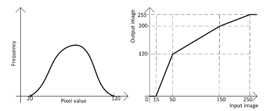
The contingency table below is obtained after an image classification. The overall classification accuracy ( ) is given as 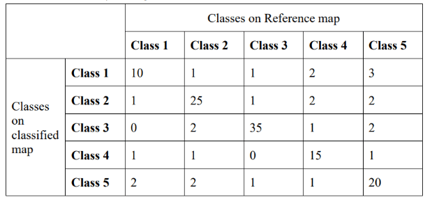
A CCD array element in a remote sensing sensor measures incoming radiation and its output voltage varies linearly between 0 V to 5 V. This voltage is converted to an 8-bit digital image using an analogue to digital convertor (ADC). The ADC has a linear response without bias or noise. If the output image pixel has a digital number of 100, the input voltage to the ADC would be _________ V (rounded off to 2 decimal places).}
A CCD array element in a remote sensing sensor measures incoming radiation and its output voltage varies linearly between 0 V to 5 V. This voltage is converted to an 8-bit digital image using an analogue to digital convertor (ADC). The ADC has a linear response without bias or noise. If the output image pixel has a digital number of 100, the input voltage to the ADC would be __________ V (rounded off to 2 decimal places).
Clouds appear white in optical visible spectral bands of remote sensing images due to _________ scattering.
About Remote Sensing - GATE-GE
Remote Sensing is a vital chapter for GATE-GE aspirants. Mastering the concepts covered in this chapter is essential for securing a top rank.
By rigorously practicing the previous year questions associated with this chapter, you can identify high-yield topics, understand the examiner's perspective, and boost your confidence during the actual exam.
Frequently Asked Questions
Why focus on Remote Sensing PYQs?
Analyzing PYQs for this specific chapter reveals the most frequently tested concepts and the typical complexity of questions, allowing you to tailor your study plan efficiently.
How to best use this analysis?
Review the topic breakdown to see which sub-topics within Remote Sensing carry the most weight. Then, tackle the questions iteratively to solidify your understanding.