GATE-GE SERIES
Geomatics-engineering

Geographic Information System Gis

23 previous year questions.

Volume: 23 Ques
Yield: High

High-Yield Trend

1
2026
2
2025
12
2024
8
2023

Chapter Questions
23 MCQs

01
PYQ 2023
medium
geomatics-engineering ID: gate-ge-
The relative radiance value of a facet of a Triangulated Irregular Network (TIN) can be computed using: Where, is the relative radiance value of a facet, is the facet’s aspect, is the sun’s azimuth angle, is the facet’s slope and is the sun’s altitude. Suppose a facet of a TIN has a slope value of and an aspect value of and sun’s azimuth of . For sun’s altitude angle of , the relative radiance value of this facet is ................. (Rounded off to 2 decimal places).
02
PYQ 2023
medium
geomatics-engineering ID: gate-ge-

In the network shown below, after converting it to a topological graph, which of the following statement(s) is/are TRUE? (Assume there are no pseudo-nodes)

1
The correct number of nodes (or vertices) are 7
2
The correct number of edges (or links) are 9
3
The total number of regions are 4
4
The correct number of edges (or links) are 8
03
PYQ 2023
medium
geomatics-engineering ID: gate-ge-

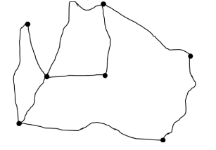
Match the following errors (Column 1) in spatial data digitization with their descriptions (Column 2).

Column 1Column 2
(P) Mis-located entities2) Points, lines or boundary segments digitized in wrong place
(Q) Missing labels4) Undefined polygons
(R) Artefacts of digitization3) Undershoots, overshoots, wrongly placed nodes, loops or spikes
(S) Duplicate labels5) Two or more identification labels for same polygon
(T) Duplicate entities1) Points, lines or boundary segments digitized twice
1
P-2, Q-4, R-3, S-5, T-1
2
P-1, Q-2, R-3, S-5, T-4
3
P-2, Q-1, R-4, S-3, T-5
4
P-2, Q-4, R-3, S-1, T-5
04
PYQ 2023
medium
geomatics-engineering ID: gate-ge-
The minimum number of 2-dimensional ground control points (GCPs) required for second-order polynomial mapping for image georeferencing is:
1
4
2
5
3
6
4
7
05
PYQ 2023
medium
geomatics-engineering ID: gate-ge-
Which of the following statement(s) is/are TRUE?
1
Topography is an example of continuous spatial feature
2
Geo-relational data model stores spatial data and attribute data separately
3
Object based data model stores spatial data and attribute data together
4
Land surface temperature is an example of discrete spatial feature
06
PYQ 2023
medium
geomatics-engineering ID: gate-ge-
Which of the following type(s) of tolerances is/are used in editing GIS data?
1
Snap tolerance
2
Weed tolerance
3
Grain tolerance
4
Polygon tolerance
07
PYQ 2023
medium
geomatics-engineering ID: gate-ge-
A GIS analyst has two raster datasets with the same number of rows and columns. The analyst computes the average of the two input raster layers to generate a new raster layer with the same size as the input raster layers. What type of raster data analysis operation is performed?
1
Local
2
Neighborhood
3
Zonal
4
Global
08
PYQ 2023
medium
geomatics-engineering ID: gate-ge-
Which vector data analysis tool combines geometries and attributes from different layers?
1
Overlay
2
Map Manipulation
3
Buffer
4
Cartesian distance measurement
09
PYQ 2024
medium
geomatics-engineering ID: gate-ge-
In the context of satellite image classification, which of the following statements is/are CORRECT?
1
Both ANN and Fuzzy C-means clustering are parametric classifiers
2
Both ANN and Fuzzy C-means clustering are non-parametric classifiers
3
ANN can be both supervised and unsupervised classification method
4
Fuzzy C-means clustering is a supervised classification method
10
PYQ 2024
medium
geomatics-engineering ID: gate-ge-
Consider a point A on the surface of Earth, its elevation with respect to EGM2008 (geoid) is 95.5 m. The geoidal undulation at point A is 4.5 m. The orthometric height of point A is _______ m (rounded off to one decimal place).
11
PYQ 2024
medium
geomatics-engineering ID: gate-ge-
Which of the following is/are method(s) used for compact storage of raster GIS data?
1
Chain code
2
Run-length code
3
Quadtree
4
Decision-tree
12
PYQ 2024
medium
geomatics-engineering ID: gate-ge-
Which of the following statements is/are INCORRECT in the context of GIS?
1
CLIP erases a part of one of the input layers.
2
SPLIT overlays polygons and keeps all areas in both layers.
3
INTERSECT overlays polygons and keeps only the common portions of both layers.
4
UNION overlays polygons and keeps all areas in both layers.
13
PYQ 2024
medium
geomatics-engineering ID: gate-ge-
In GIS, buffer is a zone with a specified width surrounding a spatial feature. Which of the following statements regarding buffer is/are CORRECT?
1
For a point feature, buffer is an ellipse with mirnor and major axes as buffer distances
2
For a line feature, buffer is a band with a specified distance created around the line conforming to the line's curve
3
Buffer zones are polylines
4
For a polygon feature, buffer is a belt of a specified distance from the edge of the polygon and conforming to its shape
14
PYQ 2024
medium
geomatics-engineering ID: gate-ge-
Which of the following errors is/are corrected in Differential GPS (DGPS)?
1
Tropospheric delays
2
Orbital errors
3
Ionospheric delays
4
Ambiguity in atomic clocks
15
PYQ 2024
medium
geomatics-engineering ID: gate-ge-
Which of the following factors is/are responsible for ionospheric delay in GNSS observations?
1
Total electron count in the ionosphere
2
Carrier signal frequency
3
Size of GPS reciever
4
Size and accuracy of atomic clocks
16
PYQ 2024
medium
geomatics-engineering ID: gate-ge-
Which of the following is a core vector GIS operation?
1
Overlaying
2
Contrast stretching
3
Histogram equalization
4
Band ratioing
17
PYQ 2024
medium
geomatics-engineering ID: gate-ge-
How many NAVSTAR GPS satellites in standard constellation are operational and provide uninterrupted service?
1
4
2
12
3
24
4
36
18
PYQ 2024
medium
geomatics-engineering ID: gate-ge-
Dilution of Precision (DOP) in GPS based survey is primarily used to assess the quality of
1
satellite's altitude
2
satellite's geometry
3
satellite's atomic clocks
4
satellite's velocity
19
PYQ 2024
medium
geomatics-engineering ID: gate-ge-
Which of the following is NOT a segment of GPS to determine position and time?
1
Space segment
2
Control segment
3
Launch segment
4
User segment
20
PYQ 2024
medium
geomatics-engineering ID: gate-ge-
Which of the following mathematical principles is applied for finding a geographic position on Earth's surface using GPS?
1
Triangulation
2
Analytical traversing
3
Trilateration
4
Analytical leveling
21
PYQ 2025
medium
geomatics-engineering ID: gate-ge-
Which one of the following statements is NOT correct in the context of shapefile?
1

2

3

4

22
PYQ 2025
medium
geomatics-engineering ID: gate-ge-
In a Geographic Information System database, a stream is represented by a line and houses are represented by polygons. The pollution in the stream is affecting houses within a distance of 500 m on both sides. Which vector data analysis operations should be performed to identify houses affected by the pollution in the stream?
1
Buffer and Overlay
2
Dissolve and Overlay
3
Buffer
4
Split
23
PYQ 2026
medium
geomatics-engineering ID: gate-ge-
Which data model represents geographic features using points, lines, and polygons?
1
Raster model
2
Vector model
3
DEM model
4
TIN model