Two statements are given below. They are Assertion and Reason (R). Read both the statements carefully and choose the correct option : Assertion : ‘The agriculturally rich states of Punjab, Haryana and western Uttar Pradesh are facing the crisis of groundwater depletion.’ Reason (R) : ‘More groundwater is utilised for irrigation than water-table recharge.’
1
Both (A) and (R) are correct and (R) is correct reason of (A).
2
Both (A) and (R) are correct, but (R) is not the correct reason of (A).
3
(A) is not correct, but (R) is correct.
4
(A) is correct, but (R) is not correct.
Official Solution
Correct Option: (1)
Assertion (A): The states of Punjab, Haryana, and western Uttar Pradesh are indeed facing a crisis of groundwater depletion, largely due to the excessive extraction of groundwater for irrigation purposes, which is critical in these agriculturally intensive regions. Reason (R): It is true that more groundwater is utilized for irrigation than water-table recharge. This overuse of groundwater for irrigation purposes, especially in regions with extensive agricultural activities, is leading to a rapid decline in the water table, contributing to the groundwater depletion crisis. Hence, both Assertion (A) and Reason (R) are correct, and the reason provided in (R) correctly explains the assertion in (A).
03
PYQ 2025
medium
geographyID: cbse-cla
Choose the correctly matched pair of areas and their characteristics from the following:
1
Jhabua District - Bhil Tribe
2
Daurala Meerut - Gaddi Tribe
3
Bharmaur Tehsil - Dilapidated Houses
4
Dharavi Mumbai - Groundwater Pollution
Official Solution
Correct Option: (1)
- Jhabua District is home to the Bhil Tribe, which is one of the largest tribes in India, mainly found in Madhya Pradesh and parts of Maharashtra, Rajasthan, and Gujarat. Hence, Option (A) is correct. - Daurala Meerut is not specifically known for the Gaddi Tribe. Gaddi Tribe is found in the hills of Himachal Pradesh, so Option (B) is incorrect. - Bharmaur Tehsil is known for its scenic beauty and not for dilapidated houses, making Option (C) incorrect. - Dharavi, located in Mumbai, is indeed a heavily populated area, but its major issue is overcrowding, poor sanitation, and the lack of adequate infrastructure, not just groundwater pollution. So, Option (D) is incorrect. Thus, the correct answer is (A) Jhabua District - Bhil Tribe.
04
PYQ 2025
medium
geographyID: cbse-cla
Read the following statements related to Indira Gandhi Canal Project carefully and choose the correct option :
(i) Indira Gandhi Canal project was conceived by Kanwar Sain in 1950 and it was launched in 1961.
(ii) Introduction of canal irrigation has brought perceptible changes in the agricultural economy of the command area.
(iii) Spread of canal irrigation has led to increase in cultivated area and crop intensity.
(iv) Traditional crops of jowar, bajra has been replaced by rice and wheat etc.
1
(i), (ii) and (iv) only are correct.
2
(i), (ii) and (iii) only are correct.
3
(i), (iii) and (iv) only are correct.
4
(ii), (iii) and (iv) only are correct.
Official Solution
Correct Option: (4)
Statement (i): The Indira Gandhi Canal project was conceived by Kanwar Sain in the early 1950s, but it was launched later in 1958, not 1961. Thus, this statement is incorrect. Statement (ii): The introduction of canal irrigation in the command areas of the Indira Gandhi Canal project has indeed brought perceptible changes in the agricultural economy, especially through increased agricultural productivity. This statement is correct. Statement (iii): The spread of canal irrigation in Rajasthan and the surrounding areas has led to an increase in both the cultivated area and crop intensity, particularly benefiting crops that require more water, such as rice and wheat. This statement is correct. Statement (iv): Traditional crops like jowar and bajra, which were suited to the arid conditions, have been replaced by water-intensive crops such as rice and wheat due to the availability of irrigation. This statement is also correct. Thus, only statements (ii), (iii), and (iv) are correct, making option (D) the right choice.
05
PYQ 2025
medium
geographyID: cbse-cla
Distinguish between ‘irrigated’ and ‘rainfed agriculture’ in India with examples.
Official Solution
Correct Option: (1)
Irrigated Agriculture: Irrigated agriculture refers to farming where water is supplied artificially to the crops through canals, wells, and other systems. In regions where rainfall is insufficient or erratic, irrigation is used to ensure proper crop growth. Examples: 1. Punjab and Haryana: These states are known for their extensive irrigated farming, particularly the cultivation of wheat and rice.
2. Uttar Pradesh: Large parts of Uttar Pradesh use irrigation for the cultivation of sugarcane, rice, and other crops. Rainfed Agriculture:
Rainfed agriculture depends solely on rainfall for water. In this form of agriculture, crops are grown in areas where there is sufficient rainfall or in areas where the natural water resources are inadequate. Examples: 1. Madhya Pradesh: Large areas of Madhya Pradesh rely on rainfed agriculture for crops like cotton, groundnut, and soybean.
2. Chhattisgarh: The state largely practices rainfed agriculture, cultivating paddy, pulses, and vegetables during the monsoon season.
06
PYQ 2025
medium
geographyID: cbse-cla
Define the concept of ‘Common Property Resource’. Explain any four characteristics of common property resources in India.
Official Solution
Correct Option: (1)
Common Property Resources (CPRs) are those resources that are shared by a group of people and are accessible to everyone within that group. These resources are not owned by any individual but are available to all members of the community for use. CPRs are generally managed collectively by the people with the help of informal rules and agreements. Examples include grazing lands, village commons, forests, water bodies, etc. Four characteristics of Common Property Resources in India: Accessibility: Common property resources are accessible to all members of a specific community or group. Collective management: The resources are managed collectively by the community members, either informally or through local governing bodies. Regulated use: CPRs are generally regulated in terms of their use by rules set by the community to ensure sustainability. Non-exclusive: CPRs are non-exclusive, meaning no single person can own them, and they are available to all community members.
07
PYQ 2025
medium
geographyID: cbse-cla
“The pressure on agricultural land increases not only due to the limited availability, but also by deterioration of quality of agricultural land.” In the context of this statement read the following reasons carefully and choose the correct option.
I. Soil erosion and waterlogging. II. Salinisation and alkalinisation of soil. III. Rich land fertility and multiple cropping. IV. Decline in land productivity.
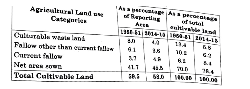
1
Only I, II and III are correct.
2
Only I, II and IV are correct.
3
Only I, III and IV are correct.
4
Only II, III and IV are correct.
Official Solution
Correct Option: (2)
The given statement highlights how the deterioration of agricultural land is contributing to increased pressure on agricultural productivity. Let's analyze the reasons provided: - Soil erosion and waterlogging: These are major contributors to the deterioration of agricultural land quality. Soil erosion removes the topsoil which is essential for plant growth, while waterlogging leads to reduced oxygen in the soil, affecting crop yields. Both contribute to the pressure on agricultural land.
- Salinisation and alkalinisation of soil: These processes involve the accumulation of salts or alkalis in the soil, which severely affects soil fertility and reduces its productivity. This is a major cause of soil degradation and increasing pressure on agricultural land.
- Rich land fertility and multiple cropping: Rich land fertility and multiple cropping are generally considered positive factors that support agricultural productivity, not factors leading to land deterioration. Therefore, this statement does not contribute to the given context.
- Decline in land productivity: This is the direct result of soil degradation caused by factors like erosion, waterlogging, salinisation, and poor farming practices. As the quality of land declines, so does its productivity. Thus, the correct option is (B) because statements I, II, and IV are valid reasons contributing to the pressure on agricultural land, whereas statement III is not.
08
PYQ 2025
medium
geographyID: cbse-cla
Explain any five problems faced by the agricultural sector in India.
Official Solution
Correct Option: (1)
The distribution of the world population is influenced by various physical, social, economic, and political factors. The key factors that affect population distribution are: Physical Factors: Natural features such as climate, soil fertility, water availability, and landforms play a significant role in determining where people live. For example, people tend to live in regions with temperate climates, fertile soils, and access to water resources, while deserts, high mountain ranges, and polar regions have sparse populations. Economic Factors: Availability of employment, industries, and economic opportunities influences population distribution. Urban areas with thriving industries and commerce tend to attract people from rural areas and less developed regions. For example, metropolitan cities like New York, London, and Tokyo have high population densities due to economic opportunities. Political Factors: Political stability and government policies can greatly influence the movement of people. Regions with peaceful political environments and favorable policies such as tax incentives, land distribution, or migration schemes tend to have a more balanced population distribution. On the other hand, regions with conflict or political instability often experience population decline or displacement. Cultural and Social Factors: Cultural, religious, and historical ties often influence where people settle. Regions with social infrastructure, such as education, healthcare, and cultural facilities, tend to attract larger populations. For instance, major cultural and religious centers like Mecca, Jerusalem, and Varanasi have significant populations due to their cultural and social importance. Technological Advances: Advances in transportation and communication technologies have made it easier for people to move and settle in previously inaccessible regions. Modern infrastructure such as highways, airports, and internet connectivity has enabled the growth of cities in areas that were once considered inhospitable.
09
PYQ 2025
medium
geographyID: cbse-cla
The successful implementation of watershed management programme in Jhabua district of Madhya Pradesh was funded by which one of the following?
1
Non-Governmental Organisation
2
Jhabua District Administration
3
Madhya Pradesh Government
4
Central Government
Official Solution
Correct Option: (1)
The Atal Tunnel, which is the world's longest highway tunnel, is located in the Pir Panjal range of the Himalayas. It connects Manali to Lahaul-Spiti Valley in Himachal Pradesh, providing year-round access to the region, even during harsh winters when roads are usually blocked by heavy snowfall. Thus, the correct answer is (A) Pir Panjal.
10
PYQ 2025
medium
geographyID: cbse-cla
Suggest any five measures to solve the main problems of Indian agriculture and explain them.
Official Solution
Correct Option: (1)
The distribution of urban population in India is highly uneven and shows significant regional variation due to geographical, historical, economic, and infrastructural factors. High Urbanisation in Western and Southern States: Maharashtra, Tamil Nadu, Gujarat, and Karnataka have higher urban populations due to early industrialisation, trade centres, and IT hubs. Cities like Mumbai, Chennai, and Bengaluru are examples. Low Urbanisation in Northern and Eastern States: States like Bihar, Odisha, and Uttar Pradesh have lower urbanisation levels due to agrarian economies, poor infrastructure, and low industrial development. Union Territories with High Urban Share: Some UTs like Delhi (urban population over 97%) and Chandigarh are highly urbanised due to being administrative and service hubs. Disparity within States: Even within a state, urban population is concentrated in specific cities while the rest of the region remains rural. Hence, urban population distribution in India is not uniform and varies significantly across regions.
11
PYQ 2025
easy
geographyID: cbse-cla
Composition of Total Cultivable Land
Categories of Reporting Area
As a percentage of total cultivable land (1950-51)
As a percentage of total cultivable land (2014-15)
Area (1950-51)
Area (2014-15)
Culturable waste land
8.0
4.0
13.4
6.8
Fallow other than current fallow
6.1
3.6
10.2
6.2
Current fallow
3.7
4.9
6.2
8.4
Net area sown
41.7
45.5
70.0
78.4
Total Cultivable Land
59.5
58.0
100.00
100.00
Official Solution
Correct Option: (1)
12
PYQ 2025
easy
geographyID: cbse-cla
Study the following table carefully and answer the Questions:
Official Solution
Correct Option: (1)
13
PYQ 2025
medium
geographyID: cbse-cla
Read the following statements related to Indira Gandhi Canal Project carefully and choose the correct option: (i) Indira Gandhi Canal project was conceived by Kanwar Sain in 1950 and it was launched in 1961. (ii) Introduction of canal irrigation has brought perceptible changes in the agricultural economy of the command area. (iii) Spread of canal irrigation has led to increase in cultivated area and crop intensity. (iv) Traditional crops of jowar, bajra have been replaced by rice and wheat etc.
1
(i), (ii) and (iv) only are correct.
2
(i), (ii) and (iii) only are correct.
3
(i), (iii) and (iv) only are correct.
4
(ii), (iii) and (iv) only are correct.
Official Solution
Correct Option: (2)
The Indira Gandhi Canal Project was initiated in 1950 and launched in 1961 to provide irrigation to the arid regions of Rajasthan. It has significantly increased the area under irrigation, which has boosted the agricultural economy. The canal irrigation has resulted in a shift in cropping patterns, with rice and wheat replacing traditional crops like jowar and bajra.
14
PYQ 2025
medium
geographyID: cbse-cla
Read the following statements related to Indira Gandhi Canal Project carefully and choose the correct option: (i) Indira Gandhi Canal project was conceived by Kanwar Sain in 1950 and it was launched in 1961. (ii) Introduction of canal irrigation has brought perceptible changes in the agricultural economy of the command area. (iii) Spread of canal irrigation has led to increase in cultivated area and crop intensity. (iv) Traditional crops of jowar, bajra have been replaced by rice and wheat etc.
1
(i), (ii) and (iv) only are correct.
2
(i), (ii) and (iii) only are correct.
3
(i), (iii) and (iv) only are correct.
4
(ii), (iii) and (iv) only are correct.
Official Solution
Correct Option: (2)
The Indira Gandhi Canal Project was initiated in 1950 and launched in 1961 to provide irrigation to the arid regions of Rajasthan. It has significantly increased the area under irrigation, which has boosted the agricultural economy. The canal irrigation has resulted in a shift in cropping patterns, with rice and wheat replacing traditional crops like jowar and bajra.