Explain the importance of rail transport in India.
Official Solution
Correct Option: (1)
Rail transport plays a significant role in India:
Connectivity: Connects remote regions to urban centers.
Economic growth: Facilitates trade and commerce by transporting goods efficiently.
Affordable travel: Provides cost-effective travel options for millions.
Employment: Employs a large workforce, directly and indirectly.
Environmental benefits: Reduces road congestion and pollution.
02
PYQ 2024
medium
geographyID: cbse-cla
"Nuclear power has emerged as a viable source in recent years." Examine the statement with suitable arguments in the context of India.
Official Solution
Correct Option: (1)
Low emissions: Nuclear energy generates power without greenhouse gas emissions. High efficiency: Produces large amounts of energy from a small amount of fuel. Energy security: Reduces dependence on fossil fuels and enhances energy security. Challenges: High initial investment and concerns over nuclear waste management. Example: India has 22 operational nuclear reactors contributing to clean energy.
03
PYQ 2025
medium
geographyID: cbse-cla
Explain the characteristics of "Trans-Canadian Railway.”
Official Solution
Correct Option: (1)
The Trans-Canadian Railway is the most important rail route in Canada, crossing the entire width of the country. Key Characteristics: Length: It is about 7,050 km long, connecting Halifax (in the east) to Vancouver (in the west). Construction: Completed in 1886, it was vital for uniting the eastern and western provinces. Economic Importance: It facilitates the movement of wheat and mining products from the interior to ports. Population Centres: The railway passes through major cities like Montreal, Ottawa, Winnipeg, and Calgary. Tourism and Trade: Plays a vital role in internal trade and tourism across Canada.
04
PYQ 2025
medium
geographyID: cbse-cla
Two statements are given below. They are Assertion (A) and Reason (R). Read both the statements carefully and choose the correct option: Assertion (A): Water transport plays an important role in the international trade of India. Reason (R): The east coast of India has more ports than its west coast.
1
Both (A) and (R) are true and (R) is the correct explanation of (A).
2
Both (A) and (R) are true, but (R) is not the correct explanation of (A).
3
(A) is correct, but (R) is incorrect.
4
(A) is incorrect, but (R) is correct.
Official Solution
Correct Option: (3)
- Assertion (A) is correct as water transport plays a crucial role in India’s international trade, with many goods being imported and exported via sea routes. - Reason (R) is incorrect. While the east coast of India has several important ports like Chennai, Kolkata, and Vishakhapatnam, the west coast has more ports in total, including major ones like Mumbai, Jawaharlal Nehru Port, and Kandla. Thus, the correct answer is (C) (A) is correct, but (R) is incorrect.
05
PYQ 2025
medium
geographyID: cbse-cla
The exported items by a port is first brought from different countries. This port is known as ______.
1
Comprehensive Port
2
Outports
3
Entrepot Ports
4
Packet Station
Official Solution
Correct Option: (3)
An entrepot port is a port where goods are brought from other countries and then stored or transferred to other destinations. These ports act as transit points for trade, where goods are imported, stored, and then re-exported to different markets. - Option (A) "Comprehensive Port" is incorrect as it does not specifically refer to a port where goods are transshipped. - Option (B) "Outports" refers to secondary ports, not specifically those used for transshipment. - Option (C) "Entrepot Ports" is correct as it is the term for ports where goods are first brought from different countries for re-export. - Option (D) "Packet Station" is incorrect and does not relate to port functions. Thus, the correct answer is (C) Entrepot Ports.
06
PYQ 2025
medium
geographyID: cbse-cla
Arrange the following airports of Asia from west to east as per their locations and choose the correct option: (i) Beijing
(ii) Tokyo
(iii) Aden
(iv) Mumbai
1
iv, iii, ii and i
2
iv, iii, i and ii
3
iii, iv, ii and i
4
iii, iv, i and ii
Official Solution
Correct Option: (4)
To arrange the airports from west to east, we need to consider their geographical locations: - Aden is the westernmost of the listed airports. - Mumbai is to the east of Aden, located in India. - Beijing is further to the east of Mumbai, in China. - Tokyo is the easternmost airport of all, located in Japan. Thus, the correct order from west to east is: Aden, Mumbai, Beijing, and Tokyo. The correct option is (D) iii, iv, i and ii.
07
PYQ 2025
medium
geographyID: cbse-cla
Read the following statements about ports carefully and choose the correct option :
(i) The ports provide the facilities of loading, unloading and storage of cargo.
(ii) The importance of ports is judged by the size of its hinterland.
(iii) The quantity of cargo handled by a port indicates the level of development of its hinterland.
(iv) Ports are the chief gateways of the world trade.
1
only (i), (ii) and (iii) are correct.
2
only (i), (iii) and (iv) are correct.
3
only (i), (ii) and (iv) are correct.
4
only (ii), (iii) and (iv) are correct.
Official Solution
Correct Option: (2)
- Statement (i): Correct. Ports indeed provide essential facilities such as loading, unloading, and storage of cargo, which are fundamental to their operation.
- Statement (ii): Incorrect. While the size of a port’s hinterland plays a role in determining its importance, other factors like location, infrastructure, and connectivity also play a significant role. The size of the hinterland alone is not the only factor in determining a port's importance.
- Statement (iii): Correct. The quantity of cargo handled by a port is often an indicator of its level of development and the economic activity in its hinterland. A port that handles a large volume of cargo typically serves a well-developed region with robust trade activity.
- Statement (iv): Correct. Ports are essential gateways for global trade, facilitating the movement of goods between countries and regions. They are central to international trade networks. Therefore, the correct answer is (B) as statements (i), (iii), and (iv) are accurate.
08
PYQ 2025
easy
geographyID: cbse-cla
Classify Indian roads on the basis of construction and maintenance and explain them.
Official Solution
Correct Option: (1)
Indian roads are classified into the following categories based on their construction and maintenance: Golden Quadrilateral: A network of highways connecting Delhi, Mumbai, Chennai, and Kolkata. Maintained by the National Highways Authority of India (NHAI). Ensures high-speed movement of goods and passengers. National Highways (NH): Connect major cities and state capitals across India. Constructed and maintained by the Central Public Works Department (CPWD) and NHAI. Serve as the backbone of road trCorrect Answerport in India. State Highways (SH): Link state capitals with district headquarters and major cities within a state. Constructed and maintained by respective State Public Works Departments (PWD). District Roads: Connect district headquarters with taluka and rural areas. Maintained by Zila Parishads and district authorities. Rural Roads: Provide connectivity to villages under the Pradhan Mantri Gram Sadak Yojana (PMGSY). Funded by central and state governments. Border Roads: Constructed and maintained by the Border Roads Organisation (BRO). Provide connectivity in strategic and remote border areas.
09
PYQ 2025
medium
geographyID: cbse-cla
Explain the characteristics of the Cape of Good Hope Sea Route.
Official Solution
Correct Option: (1)
The Cape of Good Hope Sea Route is an alternative maritime passage connecting the Atlantic and Indian OceCorrect Answer, around the southern tip of Africa. Its main characteristics are: It is a longer route compared to the Suez Canal but is used when the canal is blocked or for ships too large to pass through. The route is historically important for global trade, especially before the opening of the Suez Canal. It involves navigating the rough seas of the Southern Ocean, which can be challenging due to adverse weather conditions. It connects major ports on the Atlantic and Indian OceCorrect Answer, facilitating trade between Europe, Africa, Asia, and the Americas. The route remains strategically significant for shipping oil and goods when alternative routes are unavailable.
10
PYQ 2025
medium
geographyID: cbse-cla
Explain the characteristics of the Mediterranean–Indian Ocean Sea Route.
Official Solution
Correct Option: (1)
The Mediterranean–Indian Ocean Sea Route is a significant maritime route connecting Europe and Asia. Its main characteristics are: It connects the Mediterranean Sea to the Indian Ocean through the Suez Canal. It is a shorter and faster route compared to the traditional route around Africa, reducing travel time between Europe and Asia. The route is crucial for international trade, especially for oil trCorrect Answerport from the Middle East to Europe and other regions. It passes through strategic chokepoints like the Suez Canal and the Bab el-Mandeb Strait. The route has heavy maritime traffic and is vital for global energy security and trade.
11
PYQ 2025
medium
geographyID: cbse-cla
Explain the characteristics of "Trans-Siberian Railway.”
Official Solution
Correct Option: (1)
The Trans-Siberian Railway is the longest continuous railway line in the world and connects European Russia with the Russian Far East. Key Characteristics: Length: It stretches about 9,300 km from St. Petersburg (west) to Vladivostok (east). Construction: Built between 1891 and 1916 to link the far eastern region with industrial centres in the west. Economic Lifeline: It transports minerals, timber, and industrial products across Russia. Passenger and Freight Use: Serves both passengers and cargo across sparsely populated areas. International Link: It connects Russia with European countries in the west and Asian countries in the east.
12
PYQ 2025
medium
geographyID: cbse-cla
The objective of state highways is:
1
For inter-state transport operations.
2
For connecting important sea ports and airports.
3
To connect state capitals with district headquarters.
4
To connect the capitals of different states.
Official Solution
Correct Option: (3)
State highways are constructed and maintained by state governments and serve as major roads within a state. Option A: Refers more to national highways, which facilitate inter-state connectivity. Option B: Such connections are typically handled by national highways or expressways, not specifically by state highways. Option C:Correct. State highways connect the capital of a state to its various district headquarters and important towns within the state. Option D: This is again a function of national highways. So, the correct answer is (C): To connect state capitals with district headquarters.
13
PYQ 2025
medium
geographyID: cbse-cla
Which one of the following pairs of cities is connected by a trans-continental railway?
1
Between Yokohama and Vancouver
2
Between Auckland and Honolulu
3
Between San Francisco and New York
4
Between London and Aden
Official Solution
Correct Option: (3)
A trans-continental railway is one that spans an entire continent. The railway between San Francisco (West Coast) and New York (East Coast) in the United States is a classic example of a trans-continental railway line. Option A: Yokohama and Vancouver are in different continents and separated by the Pacific Ocean — not connected by rail. Option B: Auckland and Honolulu are also on separate islands, making rail connection impossible. Option C:Correct — San Francisco and New York are connected by one of the world's earliest and most famous trans-continental railways. Option D: London and Aden are not on the same continent and have no rail connection. So, the correct answer is (C): Between San Francisco and New York.
14
PYQ 2025
medium
geographyID: cbse-cla
The ports which have strategic importance are called:
1
Packet Stations
2
Industrial Ports
3
Comprehensive Ports
4
Naval Ports
Official Solution
Correct Option: (4)
Ports that hold strategic importance for national security and defense are known as Naval Ports. These ports are primarily used by the Navy for docking warships, conducting military operations, and maintaining maritime security. Option A: Packet Stations — Refers to ports used for passenger or cargo ships, not defense. Option B: Industrial Ports — Focus on the import/export of industrial goods. Option C: Comprehensive Ports — Handle multiple types of cargo and passengers, but not specifically strategic. Option D: Naval Ports — Correct answer; used for national defense and military purposes. So, the correct answer is (D): Naval Ports.
15
PYQ 2025
medium
geographyID: cbse-cla
How does personal communication system enable the user to establish direct contact with the world of knowledge and information? Analyse.
Official Solution
Correct Option: (1)
Personal communication systems, such as mobile phones, the internet, and other communication technologies, enable individuals to directly connect with the world of knowledge and information in various ways. These systems offer platforms where users can access vast amounts of information from different sources like academic databases, news websites, and social media platforms. - The internet serves as a central hub where users can engage in real-time communication, access digital libraries, research papers, and participate in online courses. - Social media platforms and discussion forums facilitate the sharing of knowledge across geographical boundaries. - Mobile phones enable users to communicate instantly and access educational resources, research papers, and news. Thus, the personal communication system empowers users to explore the global world of knowledge at their convenience and location, contributing to their personal growth and learning.
16
PYQ 2025
medium
geographyID: cbse-cla
Explain the main characteristics of 'Konkan Railway'.
Official Solution
Correct Option: (1)
Ports that hold strategic importance for national security and defense are known as Naval Ports. These ports are primarily used by the Navy for docking warships, conducting military operations, and maintaining maritime security. Option A: Packet Stations — Refers to ports used for passenger or cargo ships, not defense. Option B: Industrial Ports — Focus on the import/export of industrial goods. Option C: Comprehensive Ports — Handle multiple types of cargo and passengers, but not specifically strategic. Option D: Naval Ports — Correct answer; used for national defense and military purposes. So, the correct answer is (D): Naval Ports.
17
PYQ 2025
medium
geographyID: cbse-cla
Explain the main characteristics of Mumbai sea port and its hinterland.
Official Solution
Correct Option: (1)
Mumbai Port is the largest natural harbour port in India and plays a key role in India’s maritime trade.
Natural Harbour: Mumbai Port is a natural deep-sea harbour, well-sheltered by the Konkan coast, which provides safe anchorage.
Largest Port in India: It handles large volumes of cargo, including petroleum products, chemicals, textiles, machinery, and electronic goods.
Well-Connected Infrastructure: The port has excellent connectivity via road, rail, and air, supporting fast inland distribution.
Modern Facilities: Equipped with modern facilities like container terminals and dry docks for ship repair and maintenance.
Hinterland: It serves a vast and economically important hinterland including Maharashtra, Madhya Pradesh, Gujarat, Karnataka, Telangana, and parts of northern India.
18
PYQ 2025
medium
geographyID: cbse-cla
Explain the main characteristics of Kolkata sea port and its hinterland.
Official Solution
Correct Option: (1)
Kolkata Port is one of the major riverine ports of India, located on the Hooghly River in West Bengal. It plays a vital role in the eastern region’s trade and commerce.
Riverine Port: It is the only major riverine port in India, situated about 128 km inland from the Bay of Bengal.
Tidal Port: The port experiences tidal effects, requiring continuous dredging to maintain navigability.
Twin Dock Systems: It has two dock systems — Kolkata Dock System and Haldia Dock Complex.
Oldest Operating Port: Kolkata Port is one of the oldest operating ports in India, serving as a gateway for trade with East and Southeast Asia.
Hinterland: The port serves a large hinterland including West Bengal, Bihar, Jharkhand, eastern Uttar Pradesh, Assam, and the landlocked countries of Nepal and Bhutan.
19
PYQ 2025
medium
geographyID: cbse-cla
Explain the main features of the 'Bharatmala Project' for road connectivity.
Official Solution
Correct Option: (1)
Humanistic Approach of Human Geography
The humanistic approach of human geography focuses on understanding the world from the perspective of individuals and communities, emphasizing human experiences, values, emotions, and subjective meanings.
This approach emerged as a response to the more deterministic and scientific perspectives in geography that focused on physical factors or economic models. It emphasizes how people perceive, experience, and interact with their environment.
Key features of the humanistic approach include:
Focus on human agency: The ability of individuals to shape their own lives and environments.
Exploration of human emotions and creativity: Understanding subjective experiences of place, space, and identity.
Emphasis on cultural landscapes: Highlighting how societies transform surroundings through cultural, social, and political processes.
Attention to marginalized groups: Considering the spatial practices and experiences of less-represented communities.
Humanistic geography promotes an understanding of the complexity and diversity of human experiences in relation to their surroundings, seeking to understand the meaning that places and spaces have for people.
20
PYQ 2025
medium
geographyID: cbse-cla
Choose the correctly matched pair.
1
Mining — Singrauli
2
Garrison — Kandla
3
Transport — Modinagar
4
Administrative — Pilani
Official Solution
Correct Option: (1)
The Namami Gange Programme is a comprehensive initiative to clean and rejuvenate the Ganga river. One of its key objectives is to monitor and control the discharge of industrial effluents into the river, which is a significant source of pollution. Monitoring industrial effluents is essential for ensuring that industries comply with environmental regulations and that the river's water quality is improved. - The programme aims to reduce the pollution load from industries and other human activities, which directly impacts the health of the Ganga river.
- Other objectives of the programme include the development of sewage treatment plants, solid waste management, and the promotion of public awareness. Thus, the correct option is (A) because one of the core objectives of the Namami Gange Programme is to monitor industrial effluents.
21
PYQ 2025
medium
geographyID: cbse-cla
Two statements are given below. They are Assertion (A) and Reason (R). Read both the statements carefully and choose the correct option. % Assertion Assertion (A): The significance of Kolkata sea port has declined in recent times. % Reason Reason (R): Kolkata port is confronted with the problem of silt accumulation in the Hugli river.
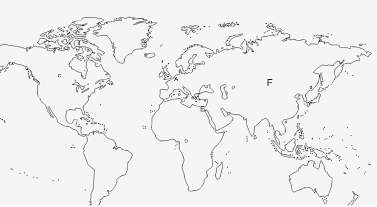
1
Both (A) and (R) are true and (R) is the correct explanation of (A).
2
Both (A) and (R) are true, but (R) is not the correct explanation of (A).
3
(A) is incorrect, but (R) is correct.
4
(A) is correct, but (R) is incorrect.
Official Solution
Correct Option: (1)
- Assertion (A) is correct because the significance of Kolkata port has indeed declined in recent times. The port, which was once a major port for trade, has seen a reduction in its prominence due to various factors including silt accumulation and shifting trade routes. - Reason (R) is also true. Kolkata port is indeed faced with the problem of silt accumulation in the Hugli river, which has led to reduced navigability and has affected the port's ability to handle large ships. This has been a major reason for the decline in its significance. Thus, both statements (A) and (R) are correct, and (R) provides the correct explanation for (A).
22
PYQ 2025
medium
geographyID: cbse-cla
The objective of Border Roads Organisation is:
Official Solution
Correct Option: (1)
The Border Roads Organisation (BRO) was established with the primary objective of constructing and maintaining roads in high altitude mountainous terrains, particularly along India's borders. This includes regions in the Himalayan and northeastern areas where road construction is particularly challenging due to the difficult terrain and strategic importance. Option (B) correctly identifies the main role of the BRO, while the other options focus on regions that are not its primary focus. Thus, the correct answer is (B) To construct roads in high altitude mountainous terrains.
23
PYQ 2025
medium
geographyID: cbse-cla
Choose the correctly matched pair of sea ports and their examples.
1
Out Ports – Duisburg
2
Ports of Call – Piraeus
3
Oil Ports – Tripoli
4
Naval Ports – Kolkata
Official Solution
Correct Option: (3)
- Out ports are ports that serve as terminals for inland transportation but are not directly connected to sea routes, such as Duisburg, which is not a correct match for this category. - Ports of call, like Piraeus, are ports where ships stop during their journey but are not necessarily hubs for oil shipping or naval activities. - Oil ports like Tripoli, located in Libya, are specifically designed for the export of oil and related products, which makes this the correct match for "Oil Ports." - Naval ports, such as Kolkata, are military ports with strategic naval importance, but they are not directly related to the oil export industry. Thus, the correct answer is (C), where Tripoli is the example of an Oil Port.
24
PYQ 2025
medium
geographyID: cbse-cla
Arrange the following sea ports from Europe to India before the operation of Suez Canal and choose the correct option. I. Cape Town II. Mombasa III. London IV. Mumbai
1
I, II, III, IV
2
I, III, II, IV
3
III, II, I, IV
4
III, I, II, IV
Official Solution
Correct Option: (4)
Before the operation of the Suez Canal, the sea route from Europe to India was much longer as ships had to bypass the southern tip of Africa, passing through the Cape of Good Hope (Cape Town). - Starting from London (III), ships would travel around the Cape of Good Hope (I) at Cape Town. - From Cape Town, the next stop would be Mombasa (II), and then the ships would arrive at Mumbai (IV), which was a major port in India at the time. Therefore, the correct order of ports before the Suez Canal operation is: London (III), Cape Town (I), Mombasa (II), and Mumbai (IV). Thus, the correct option is (D).
25
PYQ 2025
medium
geographyID: cbse-cla
Identify the correct option related to transport services from the following.
1
It comes under the quaternary sector of economic activities.
2
It is an organised industry which provides man’s basic needs of physical mobility.
3
It is concerned with digital sending and receiving of information.
4
Roads, railways, television and internet are some of its examples.
Official Solution
Correct Option: (2)
Transport services are an essential part of human mobility and involve the movement of people and goods. These services fall under the secondary and tertiary sectors of the economy, not the quaternary sector, which involves knowledge-based activities. Option (B) is correct because transport is indeed an organized industry that provides a fundamental need for physical mobility, including public and private transport systems. Option (A) is incorrect because transport services do not fall under the quaternary sector; they belong to the tertiary sector of economic activities. Option (C) is incorrect because digital sending and receiving of information is related to the information and communication technology (ICT) sector, not transport. Option (D) is incorrect because while roads and railways are examples of transport, television and the internet are communication technologies, not transport services.
26
PYQ 2025
easy
geographyID: cbse-cla
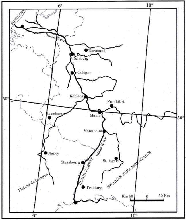
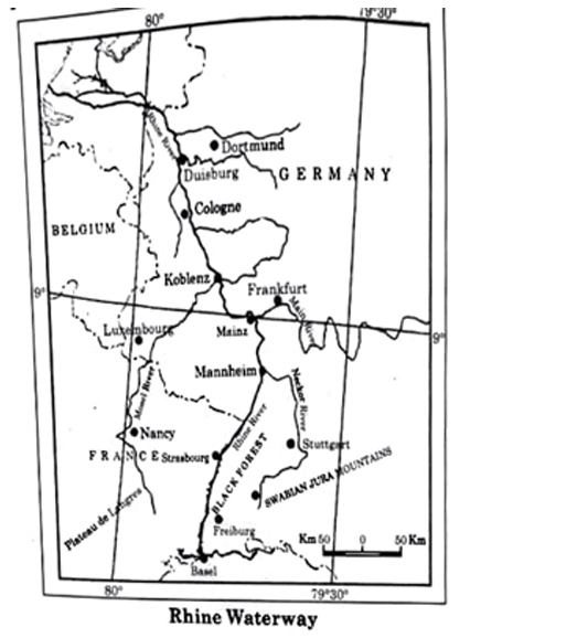
Study the map of the Rhine waterway and answer the questions that follow :
Official Solution
Correct Option: (1)
27
PYQ 2025
medium
geographyID: cbse-cla
Ports concerned with transportation passengers and mails are called ____.
1
Commercial Ports
2
Inland Ports
3
Ferry Ports
4
Naval Ports
Official Solution
Correct Option: (3)
Ferry ports are specifically designed for transporting passengers and mails. These ports are used by ferries, which are boats or ships that carry people, vehicles, and goods across bodies of water. They are particularly important for short-distance travel and for connecting islands or locations separated by water. - Commercial Ports (A) are used for the import and export of goods and are primarily concerned with bulk cargo rather than passengers and mails. - Inland Ports (B) are located along rivers or lakes and serve as trade hubs for goods transported via inland waterways. They do not focus on passenger and mail transportation. - Naval Ports (D) are military ports used for the operation and maintenance of naval vessels and not for the transportation of passengers and mails. Thus, the correct answer is (C) Ferry Ports.
28
PYQ 2025
medium
geographyID: cbse-cla
Arrange the following major airports along the western coast of America from south to north direction as per their locations and choose the correct option:
i. Mexico City
ii. Vancouver
iii. Santiago
iv. Lima
1
iv, iii, ii and i
2
iii, iv, ii and i
3
iv, iii, i and ii
4
iii, iv, i and ii
Official Solution
Correct Option: (4)
When arranging the airports from south to north along the western coast of America: - Santiago (iii) is the southernmost city on this list, located in Chile. - Lima (iv) is next, located in Peru. - Mexico City (i) is further north, in Mexico. - Vancouver (ii) is the northernmost, located in Canada. Hence, the correct order is: Santiago (iii), Lima (iv), Mexico City (i), and Vancouver (ii).
29
PYQ 2025
medium
geographyID: cbse-cla
Ports, which handle bulk and general cargo in large volume, are called ___.
1
Ferry Ports
2
Inland Ports
3
Ports of Call
4
Comprehensive Ports
Official Solution
Correct Option: (4)
Comprehensive ports (option D) are those which handle both bulk and general cargo in large volumes. They provide facilities for various types of cargo, including raw materials, machinery, and consumer goods, making them versatile and important for international trade. - Ferry Ports (A) are typically used for transporting passengers and vehicles rather than bulk cargo. - Inland Ports (B) refer to ports located inland, often on rivers or lakes, and may not always handle large volumes of cargo. - Ports of Call (C) are ports where ships stop during a journey, but they are not necessarily focused on handling large cargo volumes. Hence, option (D) is the correct answer.
30
PYQ 2025
medium
geographyID: cbse-cla
Arrange the following seaports from south to north according to their location and choose the correct option: i. Shanghai
ii. Singapore
iii. Yokohama
iv. Hong Kong
1
ii, iv, iii and i
2
ii, iv, i and iii
3
iv, ii, iii and i
4
iv, ii and iii
Official Solution
Correct Option: (2)
The correct order of seaports from south to north is: - Singapore (ii) – located at the southernmost of the options. - Hong Kong (iv) – located slightly to the north of Singapore. - Shanghai (i) – located further north, in China. - Yokohama (iii) – located at the northernmost, in Japan. Hence, the correct sequence is (ii), (iv), (i), and (iii), which corresponds to option (B).
31
PYQ 2025
medium
geographyID: cbse-cla
The world’s longest highway tunnel, Atal Tunnel is constructed across which one of the following ranges of the Himalayas ?
1
Pir Panjal
2
Karakoram
3
Zaskar
4
Ladakh
Official Solution
Correct Option: (1)
The Atal Tunnel, which is the world's longest highway tunnel, is located in the Pir Panjal range of the Himalayas. It connects Manali to Lahaul-Spiti Valley in Himachal Pradesh, providing year-round access to the region, even during harsh winters when roads are usually blocked by heavy snowfall. Thus, the correct answer is (A) Pir Panjal.
32
PYQ 2025
medium
geographyID: cbse-cla
The ports specialised in bulk cargo are called:
1
Inland Ports
2
Industrial Ports
3
Out Ports
4
Comprehensive Ports
Official Solution
Correct Option: (2)
Ports that specialize in handling large quantities of bulk goods, such as coal, iron ore, and oil, are generally called Industrial Ports. These ports are equipped with the necessary infrastructure to handle heavy and large-scale shipments of bulk cargo efficiently. - (A) Inland Ports: Inland ports are located away from the sea, typically situated on rivers or lakes and are not specifically designed for bulk cargo.
- (B) Industrial Ports: These ports are specialized in handling bulk cargo such as coal, iron, and other raw materials needed for industrial activities. This makes them the correct answer.
- (C) Out Ports: Out ports typically refer to secondary ports that complement main ports but are not specifically for bulk cargo.
- (D) Comprehensive Ports: Comprehensive ports are those capable of handling a wide variety of goods and services, but this term is not specifically associated with bulk cargo. Thus, the correct answer is (B), as industrial ports are specialized in handling bulk cargo.
33
PYQ 2025
medium
geographyID: cbse-cla
Which one of the following waterways uses the ‘Panama Canal’?
1
Between Yokohama and Vancouver
2
Between Auckland and Honolulu
3
Between San Francisco and New York
4
Between London and Aden
Official Solution
Correct Option: (3)
The Panama Canal is a key waterway that connects the Atlantic Ocean to the Pacific Ocean through the Isthmus of Panama. It allows ships to save the long and dangerous trip around the southern tip of South America. - (A) Between Yokohama and Vancouver: This route does not use the Panama Canal.
- (B) Between Auckland and Honolulu: This route does not involve the Panama Canal.
- (C) Between San Francisco and New York: This route does indeed pass through the Panama Canal as it connects the west and east coasts of the United States.
- (D) Between London and Aden: This route does not pass through the Panama Canal. Thus, the correct answer is (C), as the Panama Canal is used for shipping between the east and west coasts of the United States, including the route from San Francisco to New York.
34
PYQ 2025
medium
geographyID: cbse-cla
“Indian ports have continuously been growing for successful international trade.” Support the statement with suitable arguments.
Official Solution
Correct Option: (1)
Indian ports have played a significant role in the country’s international trade by serving as vital gateways for the import and export of goods. Here are the reasons supporting the statement:
Strategic Location: India’s ports are strategically located along its vast coastline, making it a crucial player in international maritime trade. Major ports like Mumbai, Chennai, Kolkata, and Kochi handle a significant portion of the cargo entering and leaving India, connecting the country with global markets.
Port Development: Over the years, Indian ports have undergone significant modernization and expansion. The development of new ports, such as the Mundra Port in Gujarat, has enhanced the country’s cargo handling capacity. The government’s focus on port development through initiatives like the Sagarmala Project has further facilitated the growth of the port sector.
Increasing Cargo Traffic: The continuous growth in cargo traffic at Indian ports is evident. For example, India’s ports handle a large volume of containerized cargo, petroleum, chemicals, and raw materials, playing a key role in India’s import and export economy.
Contribution to Economy: Ports serve as vital centers of trade, not only contributing to the national GDP but also driving employment in logistics, shipping, and related industries. The growth of India’s ports has also stimulated regional economic development, particularly in coastal areas.
Trade Partnerships: Indian ports have strengthened the country’s trade relations with neighboring countries and global trading partners, including the United States, China, and countries in the Middle East.
Thus, the growth of Indian ports is directly linked to the expansion of India’s international trade, driving economic prosperity.
35
PYQ 2025
medium
geographyID: cbse-cla
“Indian Railways have facilitated the movement of both freight and passengers and contributed to the growth of economy.” Support the statement with suitable arguments.
Official Solution
Correct Option: (1)
Indian Railways plays a pivotal role in the economic development of India by enabling the efficient movement of goods and people. The key arguments supporting the statement are:
Transportation of Freight: Indian Railways is one of the largest freight carriers in the world. It transports bulk goods such as coal, cement, iron, food grains, and other essential materials to various parts of the country. This is crucial for industries that depend on raw materials and resources, ensuring that goods reach their destinations in a timely and cost-effective manner.
Passenger Transportation: Railways have connected rural and urban areas, providing affordable and reliable transportation for millions of passengers every day. This has helped improve mobility, supported commuting to workplaces, and boosted economic activities by connecting markets and labor forces.
Contribution to Growth of Economy: Indian Railways has contributed significantly to India's GDP. It facilitates trade within India and with neighboring countries, making it easier to move products across states and regions. Moreover, the growth of industries such as tourism, hospitality, and retail is supported by the extensive railway network.
Job Creation: The Indian Railways network also creates a large number of jobs, contributing to employment in the country. From train operations to station management, the railways support millions of livelihoods.
Thus, Indian Railways have been instrumental in facilitating the movement of freight and passengers, boosting trade, and fostering national economic growth.
36
PYQ 2025
medium
geographyID: cbse-cla
Study the map of ‘Australian Trans-Continental Railway’ and answer the questions that follow:
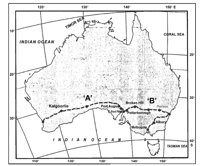
Write the names of stations located at the easternmost and westernmost ends of this railway.
Official Solution
Correct Option: (1)
- The westernmost station is Kalgoorlie. - The easternmost station is Melbourne.
37
PYQ 2025
medium
geographyID: cbse-cla
Study the map of ‘Australian Trans-Continental Railway’ and answer the questions that follow:
Identify the stations of this railway marked as ‘A’ and ‘B’.
Official Solution
Correct Option: (1)
- Station ‘A’ is Kalgoorlie, which is located in the western part of Australia. - Station ‘B’ is Melbourne, located in the southeastern part of the country.
38
PYQ 2025
medium
geographyID: cbse-cla
Study the map of ‘Australian Trans-Continental Railway’ and answer the questions that follow:
In which part of the continent this railway line is located?
Official Solution
Correct Option: (1)
The Australian Trans-Continental Railway is located in the southern part of Australia. It runs across the central and southeastern regions of the country, connecting the west coast to the east coast.
39
PYQ 2025
medium
geographyID: cbse-cla
Explain the main features of National Highways in India.
Official Solution
Correct Option: (1)
National Highways in India are the major roads that connect the capitals of different states and important cities across the country. The main features of National Highways include:
1. Network Connectivity: National Highways form the backbone of the road transportation network in India, connecting major cities, ports, and industrial regions. They ensure smooth and fast movement of goods and people.
2. Standardized Construction: These highways are constructed and maintained by the central government and have a standardized design that ensures uniformity across the country. The road quality is generally high, with wide lanes and good signage.
3. Economic Importance: National Highways facilitate the movement of essential goods and commodities across regions, making them crucial for the country’s economy. Many of them are integral to India's trade network.
4. Developmental Focus: Many National Highways pass through remote or underdeveloped areas, thus aiding in the economic development of these regions by enhancing connectivity.
5. Well-maintained: National Highways are well-maintained through a regular process of upgrading and repairs, ensuring that they are durable and reliable for transportation.
40
PYQ 2025
medium
geographyID: cbse-cla
Two statements are given below. They are Assertion and Reason (R). Read both the statements carefully and choose the correct option: Assertion : “The chief gateways of the world are harbours and ports.”
Reason (R): “Cargoes and travellers are transported through them.”
1
(A) is correct, but (R) is incorrect.
2
(A) is incorrect but (R) is correct.
3
Both (A) and (R) are correct and (R) is the correct explanation of (A).
4
Both (A) and (R) are correct, but (R) is not the correct explanation of (A).
Official Solution
Correct Option: (3)
Harbours and ports serve as the major entry and exit points for trade and travel. As the assertion indicates, they are the main gateways for global movement. The reason further clarifies that cargoes and travelers depend on ports for transportation, which is a correct explanation of their vital role.
41
PYQ 2025
medium
geographyID: cbse-cla
Read the following statements regarding outports carefully and choose the correct
option:
(i) These are deep water ports.
(ii) They are built away from the actual ports.
(iii) These ports are also known as ferry ports.
(iv) Piraeus is an example of outport for Athens in Greece.
1
Only (i), (ii), and (iii) are correct.
2
Only (i), (ii), and (iv) are correct.
3
Only (i), (iii), and (iv) are correct.
4
Only (ii), (iii), and (iv) are correct.
Official Solution
Correct Option: (1)
Outports are typically built away from the main ports and are used primarily for ferry services or as auxiliary ports. They are often not deep-water ports, as they serve smaller vessels. Piraeus, located in Greece, is an example of an outport for Athens.
42
PYQ 2025
medium
geographyID: cbse-cla
Explain the main features of State Highways in India.
Official Solution
Correct Option: (1)
State highways in India are vital components of the transportation network that connect different regions within states and link them to national highways. They play a crucial role in facilitating intra-state travel, commerce, and development. The main features of state highways include: - Connectivity: State highways connect district headquarters, towns, and cities within a state. They are critical for local transport and connectivity to national highways and rural areas. For example, the state highways in Maharashtra connect Mumbai to rural areas and smaller towns. - Road Standards: State highways are typically paved roads designed to accommodate traffic between urban and rural areas. While they are of a lower standard than national highways, they are still designed for long-distance travel and freight transport. The width of the roads may vary depending on the region's needs. - Maintenance: The state governments are responsible for the maintenance and upgrading of state highways. This includes repairing damaged sections, expanding road capacity, and ensuring smooth traffic flow. - Economic Importance: State highways contribute to the economic development of the state by facilitating the movement of goods and people. They are essential for agriculture, industries, and tourism, providing easier access to markets, resources, and services. In summary, state highways are key to the internal infrastructure of a state, supporting economic activities and improving accessibility across regions.
43
PYQ 2025
medium
geographyID: cbse-cla
Which one of the following plan was introduced to improve the conditions of roads in India?
1
Nagpur Plan
2
Golden Quadrilateral Plan
3
North-South Corridor Plan
4
Twenty-Year Road Plan
Official Solution
Correct Option: (4)
Water-borne diseases are those that are transmitted through contaminated water, which may contain harmful pathogens. Hepatitis, Diarrhoea, and Intestinal worms are classic examples of such diseases. These diseases are caused by the consumption of water contaminated with viruses, bacteria, and parasites. - Hepatitis: Caused by viral infection in water, especially Hepatitis A and E.
- Diarrhoea: Commonly caused by contaminated drinking water.
- Intestinal worms: These parasites can be ingested through contaminated water sources. Thus, the correct set of water-borne diseases is (D) Hepatitis, Diarrhoea and Intestinal worms.
44
PYQ 2025
medium
geographyID: cbse-cla
The road between Chandigarh and Manali was constructed by which of the following?
1
Border Roads Organisation
2
National Highways Authority of India
3
Central Public Works Department
4
State Public Works Department
Official Solution
Correct Option: (1)
The road connecting Chandigarh to Manali is a strategically important route, especially due to its proximity to the India-China border and the Himalayan terrain. It was constructed and is maintained by the Border Roads Organisation (BRO). The BRO is responsible for building and maintaining roads in border areas and hilly terrains. These roads are crucial for national security, tourism, and development of remote regions. BRO has played a key role in constructing all-weather roads in challenging terrains like Himachal Pradesh and Ladakh.
45
PYQ 2025
medium
geographyID: cbse-cla
Explain the main characteristics of pipeline transport system in India.
Official Solution
Correct Option: (1)
The statement that “the population of the world is unevenly distributed” is accurate and can be supported with the following arguments: Geographical Factors: Population density is high in areas with fertile soil, flat terrain, and moderate climate (e.g., the Ganga-Brahmaputra plain), while harsh climates like deserts, mountains, and polar regions (e.g., Sahara Desert, Antarctica) have sparse population. Economic Opportunities: Urban and industrial regions attract more people due to better job prospects and living standards (e.g., cities like Tokyo, New York, and Mumbai). Historical and Political Factors: Areas with early human settlements, stable governments, and infrastructural development tend to have higher population densities. Resource Availability: Regions rich in water, minerals, and energy resources support higher populations compared to resource-deficient areas. Thus, the distribution of the world’s population is highly uneven due to natural, economic, historical, and social factors.
46
PYQ 2025
medium
geographyID: cbse-cla
Read the following statements regarding inland ports carefully and choose the correct option: (i) These ports are located away from the sea coast.
(ii) These ports are linked to sea by inland water bodies.
(iii) These ports are accessible by flat-bottomed ships or barges.
(iv) Kochchi, Aden, and Honolulu are some of the examples of inland ports.
1
Only (i), (ii), and (iii) are correct.
2
Only (i), (ii), and (iv) are correct.
3
Only (i), (ii), and (iv) are correct.
4
Only (ii), (iii), and (iv) are correct.
Official Solution
Correct Option: (1)
Inland ports are typically located away from the coast, connected to the sea via inland water bodies, and accessible by flat-bottomed ships or barges. Examples of inland ports include Kochchi, Aden, and Honolulu.
47
PYQ 2025
medium
geographyID: cbse-cla
Explain the main characteristics of rural roads in India.
Official Solution
Correct Option: (1)
Rural roads in India are essential for connecting remote villages with urban centers, providing access to markets, healthcare, education, and government services. Some of the main characteristics of rural roads in India are:
1. Connectivity: Rural roads primarily aim to connect remote villages to the larger road network, improving transportation for agricultural products and daily necessities.
2. Low Traffic Volume: These roads generally have lower traffic compared to highways, often serving local traffic and vehicles for agriculture and daily commuting.
3. Basic Infrastructure: Rural roads typically have less advanced infrastructure than urban roads, with many of them being unpaved or semi-paved, especially in remote areas.
4. Limited Maintenance: Maintenance of rural roads often faces challenges due to lack of funding, harsh weather conditions, and remoteness of the areas.
5. Development Initiatives: Several government programs, such as the Pradhan Mantri Gram Sadak Yojana (PMGSY), have been implemented to improve rural roads, including all-weather connectivity. These characteristics underscore the critical role of rural roads in improving the quality of life in rural areas and ensuring their integration into national development.
48
PYQ 2025
medium
geographyID: cbse-cla
Arrange the following stations of Trans-Siberian Railway from west to east locations and choose the correct option. I. Chita II. Moscow III. Omsk IV. Kazan
1
II, IV, I, III
2
II, IV, III, I
3
IV, II, III, I
4
IV, II, I, III
Official Solution
Correct Option: (2)
The correct order of the Trans-Siberian Railway stations from west to east is: - Moscow (II) – Located in the western part of Russia. - Kazan (IV) – Located to the east of Moscow. - Omsk (III) – Located further to the east of Kazan. - Chita (I) – Located in the far east of Russia. Thus, the correct option is (B) II, IV, III, I.
49
PYQ 2025
medium
geographyID: cbse-cla
The statements given below describe communication services. Identify the most appropriate characteristics of telecommunication from the following.
1
All forms of transport are referred to as means of telecommunication.
2
Where the transport network is efficient, telecommunication is very successful.
3
Newspapers are the most efficient means of telecommunication.
4
It is linked to the development of modern technology and high speed dissemination of information. \bigskip
Official Solution
Correct Option: (4)
Telecommunication primarily refers to the transmission of information over long distances using modern technology, such as telephones, internet, and radio. It is associated with high-speed dissemination of information, which is enabled by advancements in technology. - Option (A) is incorrect as transport is not classified as telecommunication. - Option (B) is not accurate, as transport network efficiency does not directly determine the success of telecommunication. - Option (C) is also incorrect as newspapers are not the most efficient form of telecommunication in the modern context, compared to digital media. - Option (D) is correct because telecommunication involves the use of modern technologies for fast and efficient information exchange. Thus, the correct option is (D).
50
PYQ 2025
medium
geographyID: cbse-cla
“Satellites are a mode of communication in themselves as well as they regulate the use of other means of communication.” Substantiate the statement.
Official Solution
Correct Option: (1)
Satellites play a vital role in communication by enabling direct communication and regulating other communication technologies, making them indispensable in modern life. Satellites as a Mode of Communication: Satellites are an essential mode of communication, facilitating data transfer, television broadcasting, internet services, and mobile communication. Communication satellites, such as geostationary satellites, orbit Earth and relay signals across vast distances. This enables long-range communication, particularly in remote areas where terrestrial infrastructure is not feasible. - Examples of satellite communication include TV broadcasting, satellite phones, and internet services, where satellites relay signals between ground stations and provide a global coverage area. For instance, satellites like INSAT (Indian National Satellite System) provide broadcasting services across India. Regulation of Other Communication Systems: Satellites not only provide direct communication but also regulate other means of communication by acting as relays and guiding data between networks. In global positioning systems (GPS), for example, satellites regulate and support navigation, which in turn impacts road and air traffic systems worldwide. - Satellites also help in controlling communication networks by providing backup services when terrestrial systems like cables or fiber optics are damaged due to natural disasters, or in areas where ground communication infrastructure is weak. In conclusion, satellites serve as a primary communication medium while also regulating and enhancing the performance of other communication technologies.
51
PYQ 2025
medium
geographyID: cbse-cla
“In India, sea ports have emerged as gateways of international trade.” Substantiate the statement.
Official Solution
Correct Option: (1)
Sea ports play a crucial role in international trade and act as gateways for the exchange of goods between India and other countries. India, being a coastal country with a vast shoreline, has several important sea ports that facilitate maritime trade. Importance of Sea Ports in India: - India has 13 major ports and more than 200 non-major ports, including key ports like Mumbai, Kolkata, Chennai, and Kochi. These ports are pivotal in handling large volumes of cargo, including raw materials, finished products, and oil, which are vital for the Indian economy. - The major ports of India, like Mumbai, Chennai, and Kolkata, handle a significant portion of the country's exports and imports. For instance, Mumbai is the busiest port, handling cargo ranging from textiles, machinery, and chemicals to crude oil. Kolkata and Chennai are also vital for trade, especially in handling containers, bulk goods, and agricultural products. - Sea ports in India are strategically located near major shipping routes and provide an efficient mode of transportation for goods. They connect India to international markets in Europe, the Middle East, Asia, and Africa. - Furthermore, India’s focus on port modernization and infrastructural development has enhanced its capacity to accommodate larger ships and improve operational efficiency. This makes Indian sea ports more competitive in the global trade network. Thus, India's sea ports have indeed emerged as gateways to international trade, contributing significantly to the country's economy.
52
PYQ 2025
medium
geographyID: cbse-cla
Read the following statements regarding inland ports carefully and choose the correct option: (i) These ports are located away from the sea coast. (ii) These ports are linked to sea by inland water bodies. (iii) These ports are accessible by flat-bottomed ships or barges. (iv) Kochchi, Aden, and Honolulu are some of the examples of inland ports.
1
Only (i), (ii), and (iii) are correct.
2
Only (i), (ii), and (iv) are correct.
3
Only (i), (ii), and (iv) are correct.
4
Only (ii), (iii), and (iv) are correct.
Official Solution
Correct Option: (1)
Inland ports are typically located away from the coast, connected to the sea via inland water bodies, and accessible by flat-bottomed ships or barges. Examples of inland ports include Kochchi, Aden, and Honolulu.
53
PYQ 2025
easy
geographyID: cbse-cla
Study the map of Rhine waterways and answer the questions that follow:
Official Solution
Correct Option: (1)
54
PYQ 2025
easy
geographyID: cbse-cla
On the given political outline map of India, locate and label any five of the following geographical features with appropriate symbols.
Official Solution
Correct Option: (1)
55
PYQ 2025
easy
geographyID: cbse-cla
On the outline political map of the world, seven geographical features have been marked as A, B, C, D, E, F, and G. Identify any FIVE of them and write their names on the lines drawn near them:
Official Solution
Correct Option: (1)
56
PYQ 2025
medium
geographyID: cbse-cla
Explain the main features of National Highways in India.
Official Solution
Correct Option: (1)
National Highways in India are the major roads that connect the capitals of different states and important cities across the country. The main features of National Highways include:
1. Network Connectivity: National Highways form the backbone of the road transportation network in India, connecting major cities, ports, and industrial regions. They ensure smooth and fast movement of goods and people.
2. Standardized Construction: These highways are constructed and maintained by the central government and have a standardized design that ensures uniformity across the country. The road quality is generally high, with wide lanes and good signage.
3. Economic Importance: National Highways facilitate the movement of essential goods and commodities across regions, making them crucial for the country’s economy. Many of them are integral to India's trade network.
4. Developmental Focus: Many National Highways pass through remote or underdeveloped areas, thus aiding in the economic development of these regions by enhancing connectivity.
5. Well-maintained: National Highways are well-maintained through a regular process of upgrading and repairs, ensuring that they are durable and reliable for transportation.
57
PYQ 2025
medium
geographyID: cbse-cla
Choose the correct option to fill the blank: ________ were originally developed for refuelling, watering, and collecting food items.
1
Entreports
2
Ports of Call
3
Packet Stations
4
Comprehensive Ports
Official Solution
Correct Option: (2)
Ports of call were established primarily to provide facilities for ships to stop and refuel, resupply, and allow passengers to disembark. These ports serve as temporary halts during longer voyages.
58
PYQ 2025
medium
geographyID: cbse-cla
Read the following statements regarding outports carefully and choose the correct option: (i) These are deep water ports.
(ii) They are built away from the actual ports. (iii) These ports are also known as ferry ports. (iv) Piraeus is an example of outport for Athens in Greece.
1
Only (i), (ii), and (iii) are correct.
2
Only (i), (ii), and (iv) are correct.
3
Only (i), (iii), and (iv) are correct.
4
Only (ii), (iii), and (iv) are correct.
Official Solution
Correct Option: (1)
Outports are typically built away from the main ports and are used primarily for ferry services or as auxiliary ports. They are often not deep-water ports, as they serve smaller vessels. Piraeus, located in Greece, is an example of an outport for Athens.
59
PYQ 2025
medium
geographyID: cbse-cla
Two statements are given below. They are Assertion (A) and Reason (R). Read both the statements carefully and choose the correct option: Assertion (A): “The chief gateways of the world are harbours and ports.”
Reason (R): “Cargoes and travellers are transported through them.”
1
(A) is correct, but (R) is incorrect.
2
(A) is incorrect but (R) is correct.
3
Both (A) and (R) are correct and (R) is the correct explanation of (A).
4
Both (A) and (R) are correct, but (R) is not the correct explanation of (A).
Official Solution
Correct Option: (3)
Harbours and ports serve as the major entry and exit points for trade and travel. As the assertion indicates, they are the main gateways for global movement. The reason further clarifies that cargoes and travelers depend on ports for transportation, which is a correct explanation of their vital role.
60
PYQ 2025
easy
geographyID: cbse-cla
On the given political outline map of India, locate and label any five of the following geographical features with appropriate symbols.
Official Solution
Correct Option: (1)
61
PYQ 2025
medium
geographyID: cbse-cla
Read the following statements regarding inland ports carefully and choose the correct option: (i) These ports are located away from the sea coast. (ii) These ports are linked to sea by inland water bodies. (iii) These ports are accessible by flat-bottomed ships or barges. (iv) Kochchi, Aden, and Honolulu are some of the examples of inland ports.
1
Only (i), (ii), and (iii) are correct.
2
Only (i), (ii), and (iv) are correct.
3
Only (i), (ii), and (iv) are correct.
4
Only (ii), (iii), and (iv) are correct.
Official Solution
Correct Option: (1)
Inland ports are typically located away from the coast, connected to the sea via inland water bodies, and accessible by flat-bottomed ships or barges. Examples of inland ports include Kochchi, Aden, and Honolulu.
62
PYQ 2025
medium
geographyID: cbse-cla
Explain the main features of National Highways in India.
Official Solution
Correct Option: (1)
National Highways in India are the major roads that connect the capitals of different states and important cities across the country. The main features of National Highways include:
1. Network Connectivity: National Highways form the backbone of the road transportation network in India, connecting major cities, ports, and industrial regions. They ensure smooth and fast movement of goods and people.
2. Standardized Construction: These highways are constructed and maintained by the central government and have a standardized design that ensures uniformity across the country. The road quality is generally high, with wide lanes and good signage.
3. Economic Importance: National Highways facilitate the movement of essential goods and commodities across regions, making them crucial for the country’s economy. Many of them are integral to India's trade network.
4. Developmental Focus: Many National Highways pass through remote or underdeveloped areas, thus aiding in the economic development of these regions by enhancing connectivity.
5. Well-maintained: National Highways are well-maintained through a regular process of upgrading and repairs, ensuring that they are durable and reliable for transportation.
63
PYQ 2025
medium
geographyID: cbse-cla
Choose the correct option to fill the blank: ________ were originally developed for refuelling, watering, and collecting food items.
1
Entreports
2
Ports of Call
3
Packet Stations
4
Comprehensive Ports
Official Solution
Correct Option: (2)
Ports of call were established primarily to provide facilities for ships to stop and refuel, resupply, and allow passengers to disembark. These ports serve as temporary halts during longer voyages.
64
PYQ 2025
medium
geographyID: cbse-cla
Two statements are given below. They are Assertion (A) and Reason (R). Read both the statements carefully and choose the correct option: Assertion (A): “The chief gateways of the world are harbours and ports.”
Reason (R): “Cargoes and travellers are transported through them.”
1
(A) is correct, but (R) is incorrect.
2
(A) is incorrect but (R) is correct.
3
Both (A) and (R) are correct and (R) is the correct explanation of (A).
4
Both (A) and (R) are correct, but (R) is not the correct explanation of (A).
Official Solution
Correct Option: (3)
Harbours and ports serve as the major entry and exit points for trade and travel. As the assertion indicates, they are the main gateways for global movement. The reason further clarifies that cargoes and travelers depend on ports for transportation, which is a correct explanation of their vital role.
65
PYQ 2025
medium
geographyID: cbse-cla
Read the following statements regarding outports carefully and choose the correct option: (i) These are deep water ports.
(ii) They are built away from the actual ports. (iii) These ports are also known as ferry ports. (iv) Piraeus is an example of outport for Athens in Greece.
1
Only (i), (ii), and (iii) are correct.
2
Only (i), (ii), and (iv) are correct.
3
Only (i), (iii), and (iv) are correct.
4
Only (ii), (iii), and (iv) are correct.
Official Solution
Correct Option: (1)
Outports are typically built away from the main ports and are used primarily for ferry services or as auxiliary ports. They are often not deep-water ports, as they serve smaller vessels. Piraeus, located in Greece, is an example of an outport for Athens.