Map Work
20 previous year questions.
High-Yield Trend
Chapter Questions 20 MCQs
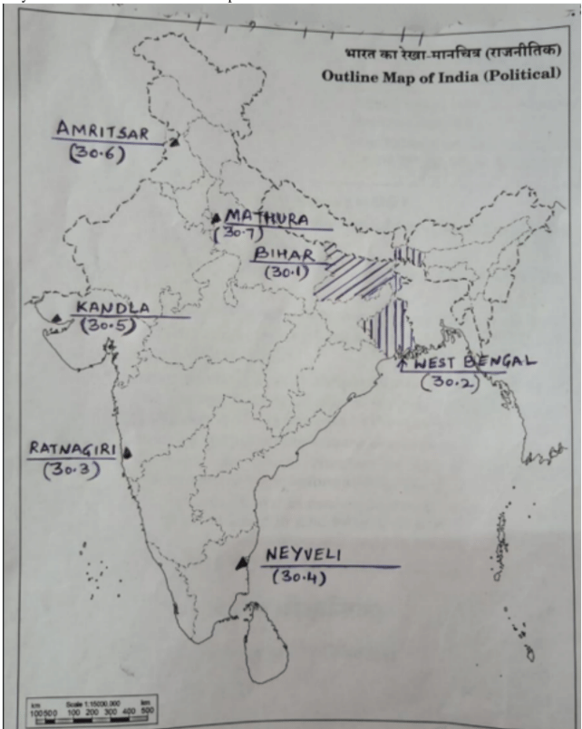
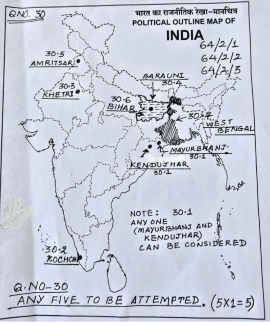
(30.1) The state with the highest population density
(30.2) The leading rice producing state
(30.3) Important iron ore mines located in coastal Maharashtra
(30.4) Important coal mines located in Tamil Nadu
(30.5) A major sea port in Gujarat
(30.6) An international airport in Punjab
(30.7) An oil refinery in Uttar Pradesh
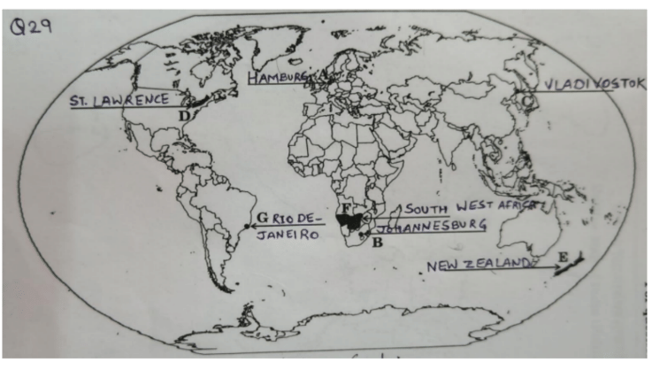
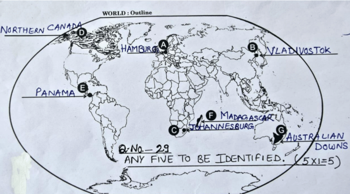
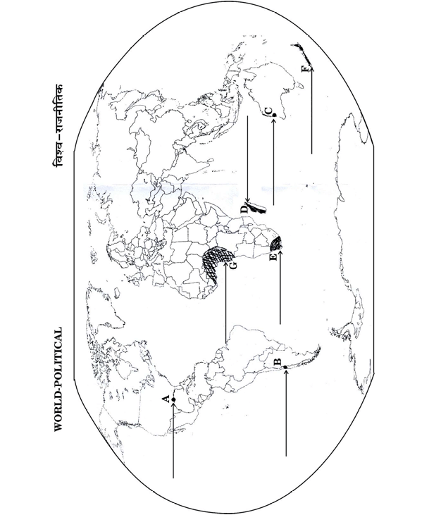
A. A major sea port
B. A major airport
C. A terminal station of Trans-Siberian Railway
D. An inland waterway
E. An area of commercial livestock rearing
F. An area of nomadic herding
G. A major sea port of South America
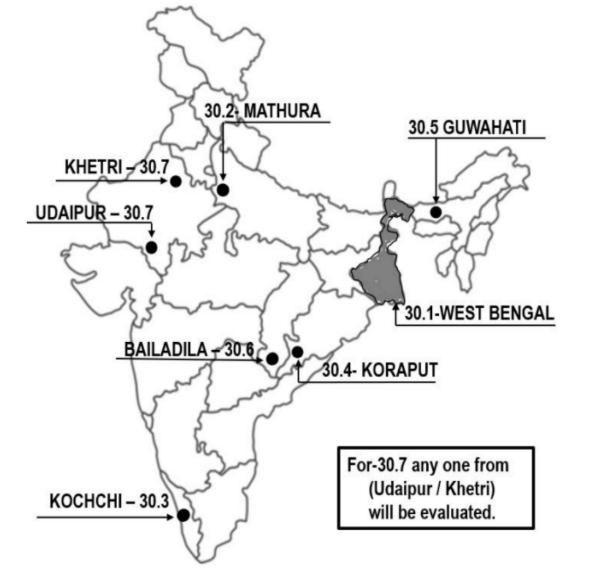
(30.1) The state leading in the production of rice
(30.2) An oil refinery in Uttar Pradesh
(30.3) The sea port situated at the head of Vembanad Kayal
(30.4) Important bauxite mines located in southern Odisha
(30.5) The international airport in Assam
(30.6) Important iron ore mines located in southern Chhattisgarh
(30.7) Important copper mines located in southern Rajasthan
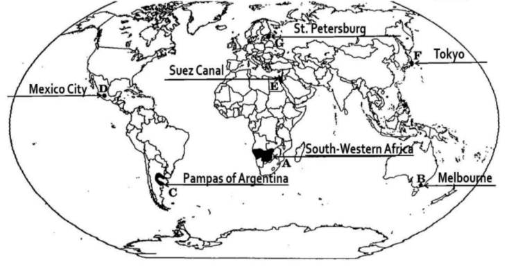
A. An area of nomadic herding
B. A major sea port
C. An area of extensive commercial grain farming
D. A major airport
E. An inland waterway
F. A major airport
G. A terminal station of a trans-continental railway
The state leading in the production of cotton
Iron ore mines located in southern part of Chhattisgarh
Copper mines located in northern part of Jharkhand
A major sea port of Goa
An international airport in Gujarat
A sea port built to relieve the pressure of Kolkata sea port
The state leading in the production of tea
A. An area of extensive commercial grain farming
B. An area of subsistence gathering
C. A major sea port
D. A major airport
E. A major sea port
F. A major area of nomadic herding
G. An inland waterway
(i) Nagpur
(ii) Hyderabad
(iii) Madurai
(iv) Lucknow
Important iron ore mines in Odisha.
An important seaport in Kerala.
A copper mine in Rajasthan.
An oil refinery in Bihar.
An international airport in Punjab.
A state with highest density of population.
A state leading in the production of jute.
A major sea port in Germany.
Terminal station of Trans-Siberian Railway.
An international airport.
An area of subsistence gathering.
An important waterway.
An area of ‘Nomadic Herding’.
An area of extensive commercial grain farming.
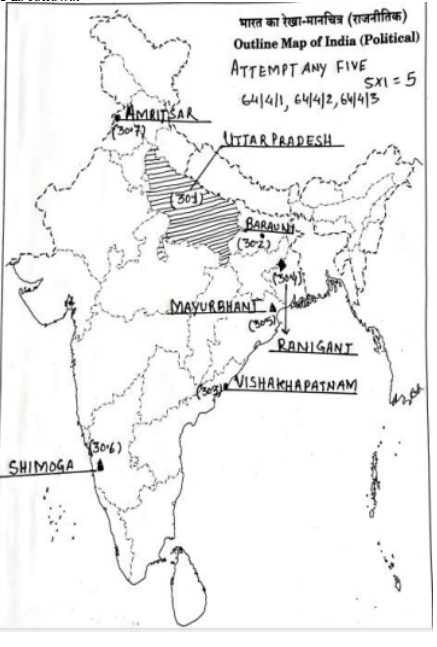
On the given political outline map of India (on page 27), locate and label any five of the following seven geographical features with appropriate symbols:
- The state leading in the production of wheat
- An oil refinery in Bihar
- A major sea port of Andhra Pradesh
- Important coal mines located in West Bengal
- Important iron ore mines located in Odisha
- Important manganese mines located in Karnataka
- An important international airport in Punjab
On the given political outline map of the world, seven geographical features have been marked as A, B, C, D, E, F, and G. Identify any five with the help of the following information and write their correct names on the lines drawn near them.
- A major sea port
- A major airport
- A terminal station of a trans-continental railway
- A major area of nomadic herding
- A major area of extensive commercial grain farming
- A major area of commercial livestock rearing
- A major area of subsistence gathering
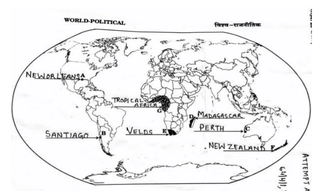
- A. A major sea-port
- B. A major air-port
- C. A major shipping canal
- D. A major area of subsistence gathering
- E. A major area of nomadic herding
- F. A major area of commercial livestock rearing
- G. A major area of extensive commercial grain farming
- The state leading in the production of sugarcane
- An oil refinery located in Bihar
- Important coal mines located in West Bengal
- Important iron-ore mines located in Coastal Maharashtra
- Important manganese mines located in Madhya Pradesh
- A major sea-port located in Odisha
- An important international airport in Telangana
About Map Work - CBSE-CLASS-XII
Map Work is a vital chapter for CBSE-CLASS-XII aspirants. Mastering the concepts covered in this chapter is essential for securing a top rank.
By rigorously practicing the previous year questions associated with this chapter, you can identify high-yield topics, understand the examiner's perspective, and boost your confidence during the actual exam.
Frequently Asked Questions
Why focus on Map Work PYQs?
Analyzing PYQs for this specific chapter reveals the most frequently tested concepts and the typical complexity of questions, allowing you to tailor your study plan efficiently.
How to best use this analysis?
Review the topic breakdown to see which sub-topics within Map Work carry the most weight. Then, tackle the questions iteratively to solidify your understanding.